Decoding Minescape Encoding Memory
Contingent Design for the Post-Mining Ladnscape in Charleroi Belgium

Project Summary
This thesis explores the terrils of Charleroi , a coal waste hills that embody the industrial memory and complex identity of Wallonia’s mining heritage. Once symbols of productivity, these monumental landforms now stand as layered landscapes shaped by ecological succession, cultural memory, and socio-economic transformation. Through historical research and site analysis, the project frames the terril as both archive and artifact, carrying stories that are not always visible but deeply felt. Using a “0-0.5-1” evaluative framework, the design navigates between extremes of over-intervention and complete preservation to find a nuanced, context-sensitive approach. Embracing a strategy of concealment and gradual revelation, interventions are subtly embedded into the terrain. These elements, including hidden trails, concrete traces, and material wear, invite visitors to interpret or rediscover the mining past over time. Rather than dictate a single narrative, the design allows memory to emerge contingently, shaped by time, weather, and human experience.
Disecting Terrils

Why Charleroi?
This city once burned bright with the fire of industry, powering a nation and shaping generations. But with that prosperity came hardship, most painfully marked by the Bois du Cazier disaster. Today, Charleroi stands at a crossroads of memory and change. Its post-mining terrain , now recognized by UNESCO , not only holds the weight of the past but also the promise of something new. It’s here, among the coal-black hills and fading factory lines, that we ask: what do we choose to remember, and what do we let fade?

The “0 - 0.5 - 1” Framework - Finding a Middle Ground for Post-Mining Landscape Interventions
Terril-centric Design:
This philosophy prioritizes the terril’s natural processes and unaltered evolution. The design allows the terril to erase human traces over time, favoring minimal intervention and emphasizing decoding the terril’s natural significance. Examples include geological stratification mapping and ecosystem-focused studies.
Terril-Human Symbiosis:
This approach seeks balance and co-existence between natural evolution and human engagement. It emphasizes mutual understanding and nuanced interactions that retain the terril’s integrity while making it accessible. Design interventions include signage, passageways, and platforms that foster interaction without overstepping ecological boundaries.
Anthropocentric Design:
This perspective sees the terril as a site for human-driven conservation and memory-making, transforming it into cultural or recreational spaces. It involves significant design interventions such as creating museums, botanical gardens, and playscapes to encode human narrati

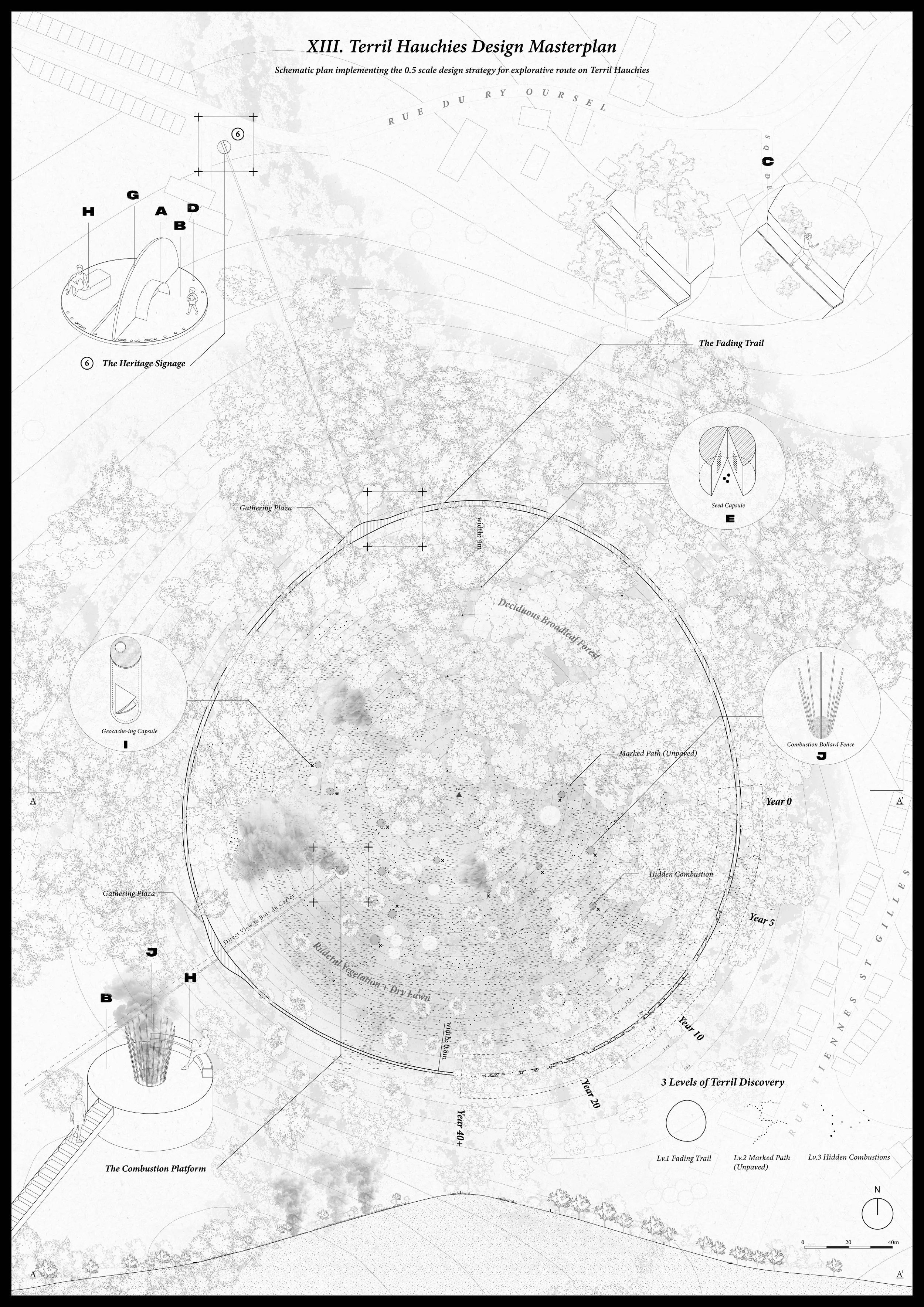
Terril Hauchies - The 0.5 Design
In the terril hauchies,we demonstrates the translation of abstract ideas into physical design actions, documenting the decision-making process, challenges, and key outcomes. Through technical drawings and experiential visualisations, the chapter highlights how abstract concepts such as chronotope and site dynamics manifest in a real-world terril context, ultimately shaping Terril Hauchies into a new prototype for post-industrial landscape design.
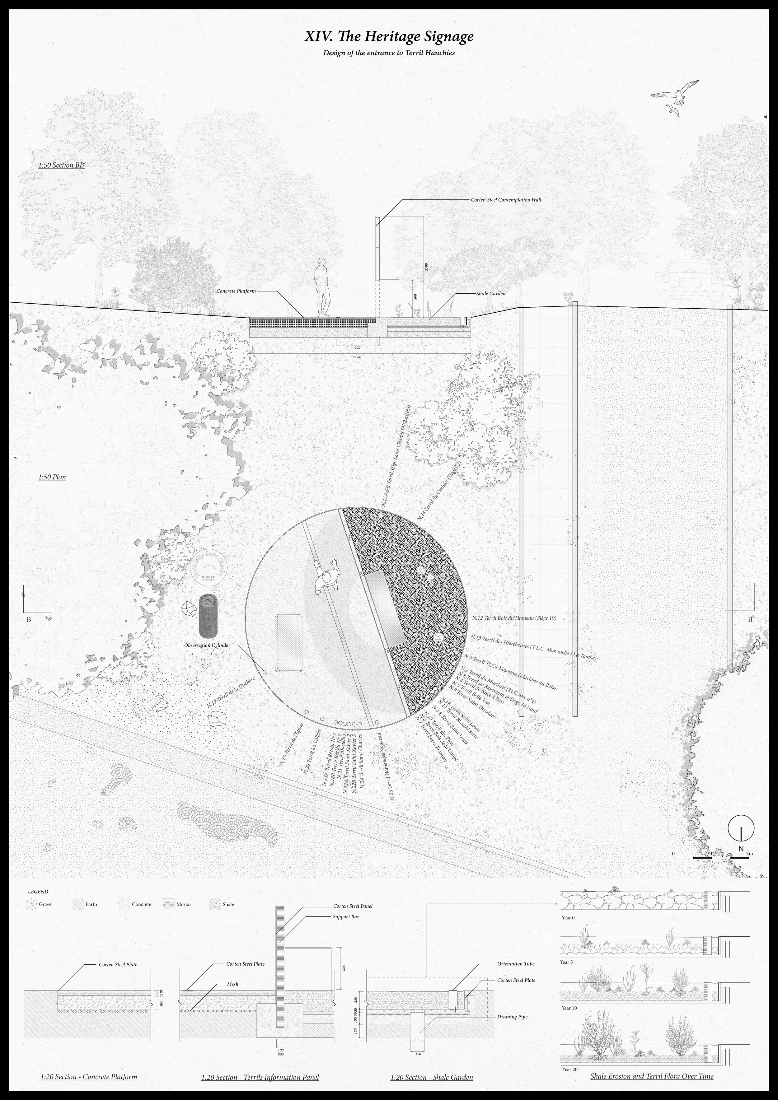
The Heritage Signage
Cylindrical markers, aligned with the orientations of other terrils across Charleroi, will also trace the movement of foot traffic—human or animal. As the shale disc beneath them gradually wears down under repeated passage, more of each cylinder will be revealed over time. The fragmented shale becomes a hospitable seedbed for plant species native to the terril. As visitors exit the site, spores and seeds clinging to their shoes are carried to these discs, turning them into micro-sample grounds that reflect the specific flora of the original terril
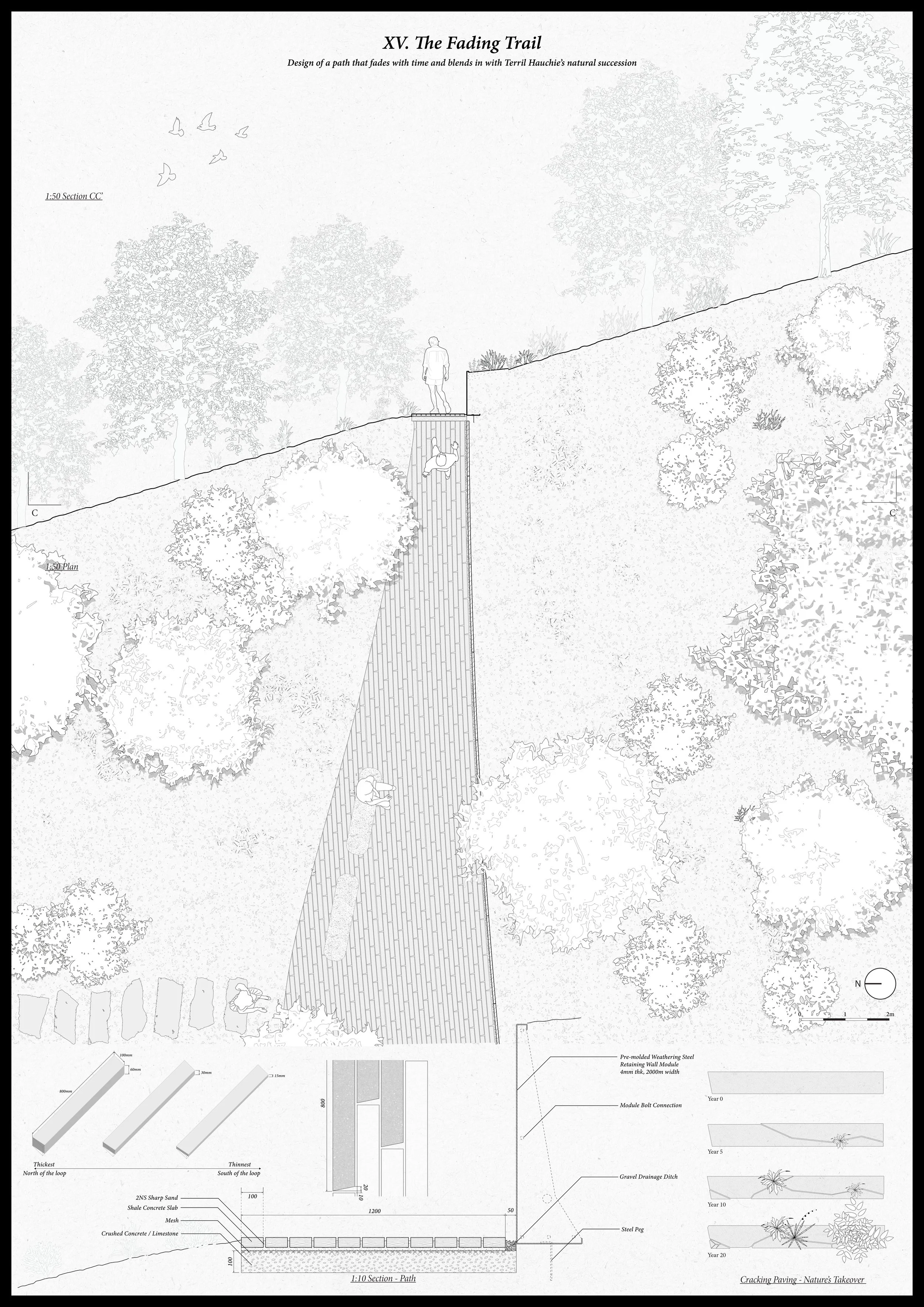
The Fading Trail
This path is paved with shale-infused concrete that varies in thickness from north to south—thicker in the lush, vegetated north and thinning out toward the sparse, barren south. The path also narrows progressively, subtly encouraging walkers to lean closer to the terril slope. This design fosters a tactile and intimate connection with the flora and geological textures, enriching the sensory experience as one moves forward.
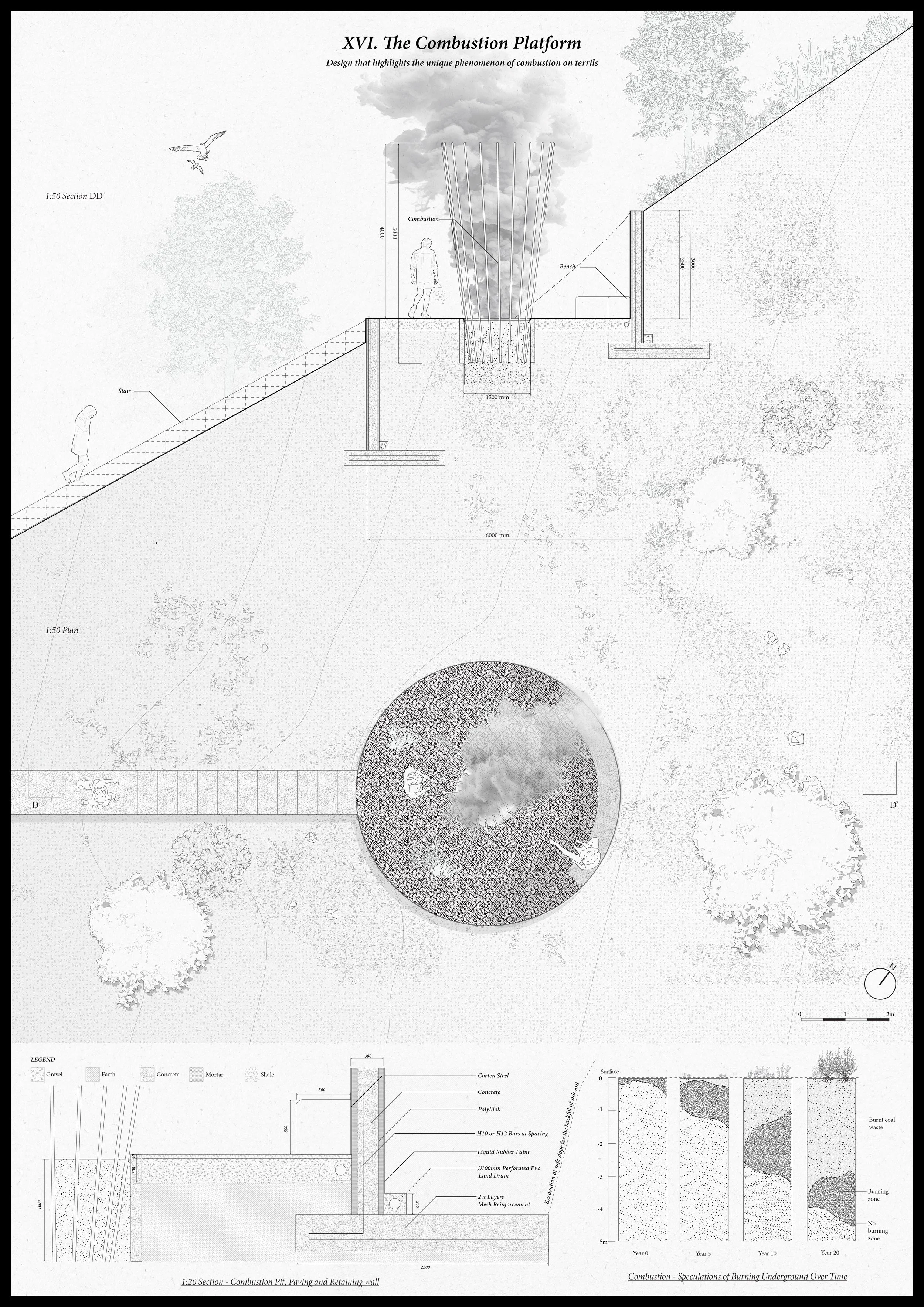
The combustion Platform
The combustion observation platform invites visitors to engage passively with the site’s unique geological phenomenon. Guardrails encircling the combustion pit serve as visual beacons, drawing attention to this subtle yet extraordinary feature of the landscape. Unlike a staged spectacle, the platform honors the natural combustion event without artificially enhancing it. Even after active burning has ceased, the structure remains a marker—a quiet symbol of the event’s presence and passage.

-
Location: Charleroi, Belgium
Type: Academic
Year: 2024
Role: Co-author
Theme: Redevelopment, Landscape Design
Institution: Politecnico di Milano
Supervised by: Prof. Matteo Umberto Poli and Thomas Cabai
Collaborated with : Tinnix Jingsu He -
Developed a sensitive and critical design approach for post-mining landscapes, balancing memory, ecology, and urban transformation.
Applied a unique “0–0.5–1” evaluation framework to analyze and critique global post-industrial landscape practices.
Proposed a design language of subtlety and concealment, allowing interventions to gradually emerge or fade—inviting personal interpretation of industrial memory.
Reframed the terril not as a blank slate but as an active palimpsest, offering a design model for landscapes grappling with collective trauma and layered heritage.
-
GIS (QGIS): Terrain analysis, spatial mapping of terrils, and regional data integration
Rhino / SketchUp: 3D terrain modeling and conceptual visualization
Adobe Illustrator: Layered diagramming and conceptual mapping
Photoshop: Atmospheric renderings and collage compositions
InDesign: Narrative sequencing and publication layout for thesis documentation
Literature & Archival Research: Integrated through annotated maps and layered historical timelines