Gold or Food?
Corporate Social Responsibility along the China-Laos Mineral Corridor

Project Summary
Set against the backdrop of rapid mining expansion in Laos, this project critically examines the social and environmental trade-offs of transnational infrastructure. Using GIS analysis, it maps the fragile livelihoods of upland communities and proposes alternative models of agricultural diversification. From intercropping fodder crops to integrating livestock farming and circular economies, the strategies aim to empower rural villagers and counteract extractive development. It’s a landscape of resistance and one that asks whether the region’s future lies in gold or in food, and offers spatial tools for resilience.
Laos: Confronting the Impacts of Extractive Development
Laos, often dubbed Asia’s last resource frontier, has been positioned as an open landscape for transnational resource extraction. Since the early 2000s, large-scale mining projects have rapidly expanded, reshaping rural regions both economically and ecologically.
With World Bank support, mining production surged from USD 8 million to USD 700 million between 2002 and 2008. Framed as a model for poverty reduction, these projects promised jobs and infrastructure upgrades. To attract foreign investment, the Bank helped establish socio-environmental standards and mediated between the Lao government and investors, laying the groundwork for an economic corridor connecting neighboring countries.
Yet the benefits came with deep costs. Resource extraction disrupted local livelihoods and fragile ecosystems, revealing the vulnerabilities of a development model driven by neoliberal growth.
Economic Corridor in Northern Laos
Reassessing the Costs of Mining
While mining revenues have surged, the long-term costs demand scrutiny. Environmental damage is unavoidable,even in limestone extraction,leading to waste rock, deforestation, and soil erosion. Heavy metal mining, like gold and copper, produces toxic tailings that contaminate water and soil.
These impacts threaten agriculture and community health. Mine closure plans often rely on weak regulations and corporate responsibility, which are rarely enough. To protect local livelihoods, it’s essential to reconsider the hidden costs of mining and explore more sustainable alternatives.


Resilient Alternatives to Mining
Government policies often label shifting cultivation as unproductive and fallow land as "barren." This project challenges that view by introducing a diversified upland agriculture system along the emerging economic corridor offering a sustainable response to mining expansion.
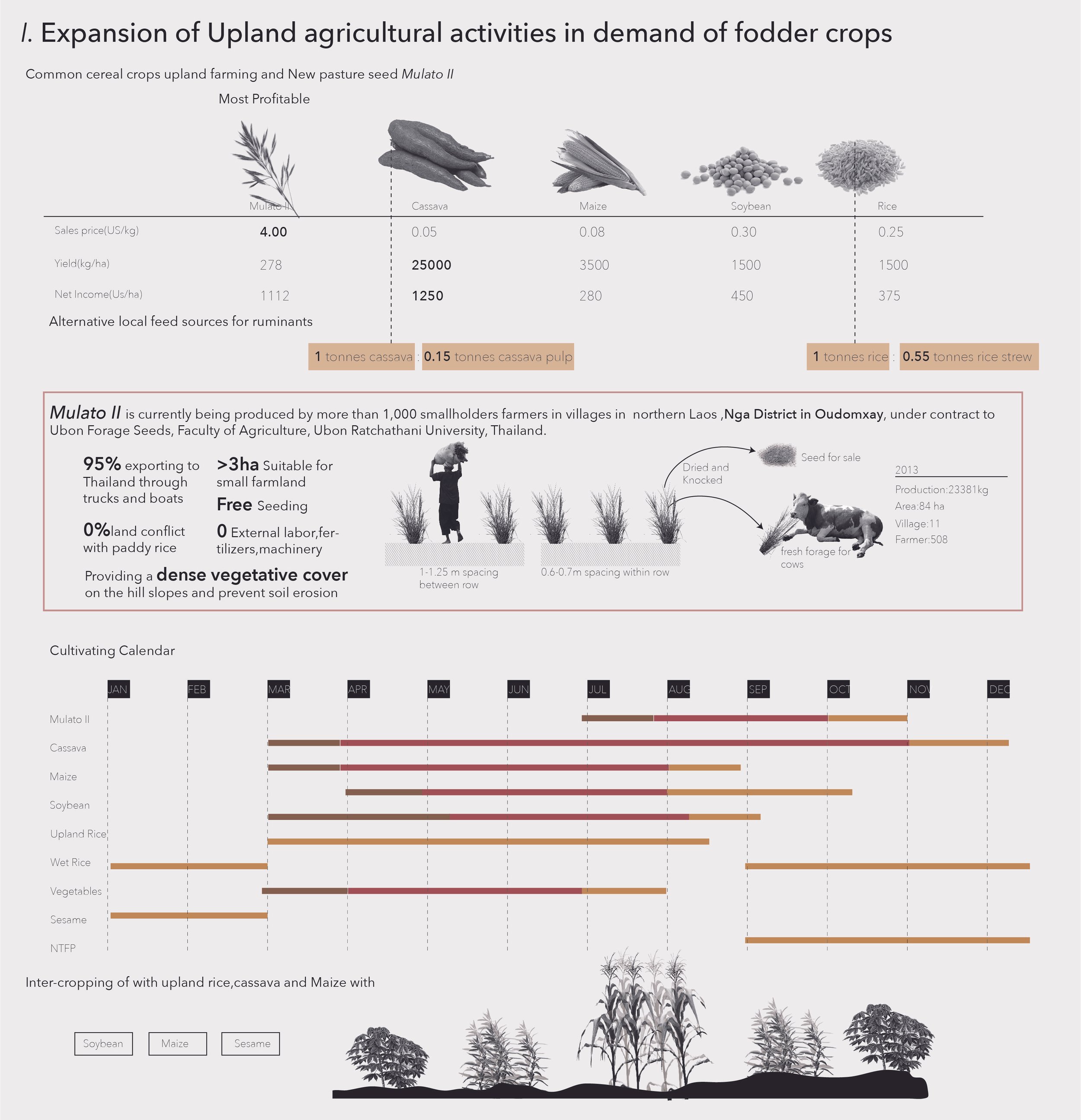
The first strategy promotes fodder crops like Mulato grass, which has shown high yields, good market value, and low environmental impact. Intercropping rice, maize, cassava, and sesame can further boost income.
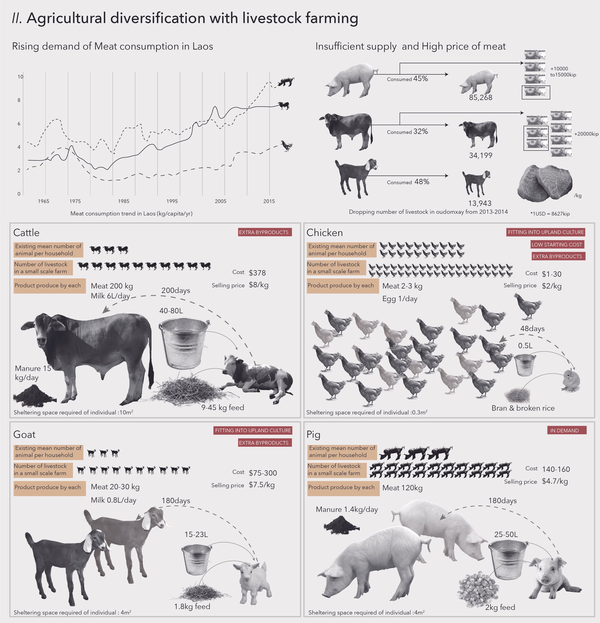
The second strategy supports small-scale livestock and poultry farming, especially near railway-linked villages. Women can lead goat and poultry production in more remote areas.
Together, these approaches form a circular economy: pig manure fertilizes fodder crops, which feed cattle potentially quadrupling productivity. More than an economic upgrade, this model builds resilience and reclaims “barren” land as productive and protective against extractive industry pressures.
-
Location: Oudomxay, Laos
Type: Academic
Year: 2019
Role: Sole Researcher and Designer
Theme: Regional Planning, Socio-environmental Analysis
Institution: The University of Hong Kong
Supervised by: Prof. Ashley Scott Kelly and Prof. Lu Xiaoxun -
Analyzed the socio-environmental impacts of mining expansion along the China-Laos corridor, focusing on vulnerable rural communities.
Investigated the trade-offs between mineral resource extraction and agricultural productivity, using GIS and stakeholder research.
Proposed integrated strategies for agricultural diversification and food security to build resilience against industrial exploitation.
Developed scenarios to visualize impacts of mining under various environmental conditions, guiding policy recommendations and local adaptation.
-
GIS (ArcGIS): Regional mapping, timeline analysis, and agricultural productivity modeling
Illustrator & Photoshop: Visual diagrams, infographics, and policy scenario illustrations
InDesign: Final report layout and academic presentation
Field Research & Data Collection: Local site study, government reports, and global economic data review